Fishermen’s Trail, Rota Vicentina
Discover the south-west region of Portugal through a fantastic coastal walk.
227 Km, 13 days | Portugal
The Fishermen’s Trail is one of Portugal’s hidden gems, offering a unique experience for trekking and nature lovers. Situated along the beautiful south-west coast of the country, this path starts in São Torpe (Sines) and ends up in Lagos, although most people decide to stop earlier (at Odeceixe) and follows the ancient routes used by local fishermen, passing through breathtaking landscapes of majestic cliffs, pristine beaches and picturesque fishing villages. With a total length of approximately 227 km, the Fishermen’s Trail is part of the Rota Vicentina, a network of trails celebrating the wild beauty and authentic culture of the Alentejo and Algarve.
In this article, there are descriptions and information on all 13 stages of the Fishermen’s Trail, but many prefer to limit themselves to the first part of the route, that between São Torpes and Odeceixe (approximately 75 km).
Obviously, the division into stages can also be changed according to one’s preference, also in view of the fact that many of them, as listed below, are rather short and could therefore be merged.
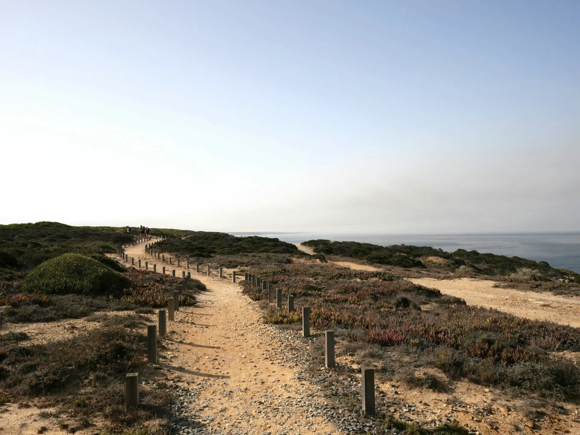
@ photo by Riccardo Gazzin on Unsplash
Transportation
The Fishermen’s Trail starts from Sines, precisely from Praia de São Torpes. Sines can be reached by bus from Lisbon and the main options are as follows:
- Rede Expressos (departures approx. every 2/3 hours | from 4€ | approx. 2h 40min);
- Flixbus (departures about 3 times a day | from 7€ | about 1h 45min).
For the return journey, if you decide to walk the entire way to Lagos, you start from the town of Lagos and, depending on whether you decide to reach Lisbon or Faro (which is much closer), you can follow these options:
- from Lagos to Lisbon (bus);
- from Lagos to Faro (train or bus).
Those who decide to end their journey at Odeceixe, can make a bus for Lisbon, lasting approximately 3h 30min.
Itinerary and stages
Stage 1 – from São Torpes to Porto Covo:
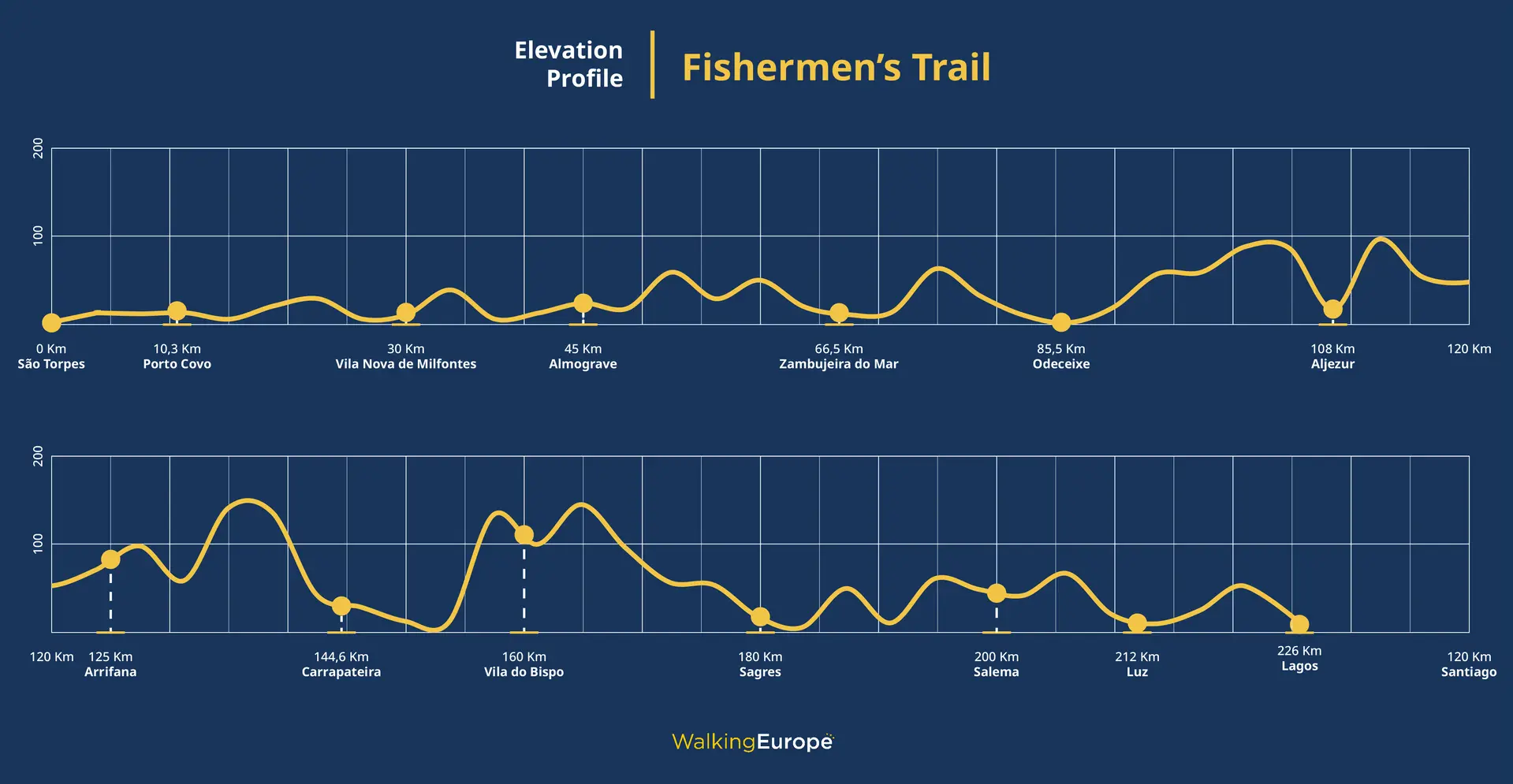
10,3 Km | 3 hours | +30m
The first stage of the Fishermen’s Trail starts south of Sines, specifically at Praia de São Torpes. One starts by leaving the industrial area behind and walking along the road for about two to three kilometres, then taking a dirt track. Continuing on, one passes the beach of Vierinha and heads towards that of Oliveirinha: near the former, depending on the tide and weather conditions, one can walk along the beach or on an alternative path;
Continuing to follow the signs, you cross a stream and face a sandy climb of about 1 km. After this section, we finally take an earthen path to Porto Covo.
Stage 2 – from Porto Covo to Vila Nova de Milfontes:
19,6 Km | 5/6 hours | +80m, -70m
We start walking from Largo do Mercado, following the signs and crossing a river and the beach of Ilha do Pessegueiro in order: there is a possible refreshment point near the latter (Restaurante A Ilha).
We continue along the path, passing the beaches of Queimado. and Malhao, between which, however, the signposting is not entirely complete: a little more care must be taken when following the path and crossing the dunes
Continuing on, you follow a track that runs parallel to the cliffs present and then, after crossing dunes and cliffs, you arrive at Porto das Barcas (where there is another refreshment point).
From here, travelling a further 2.5 km, one finally arrives at Vila Nova de Milfontes.
Stage 3 – from Vila Nova de Milfontes to Almograve:
15 Km | 4 hours | +72m, -80m
This stage begins by taking rua Custódio Brás Pacheco and crossing the Rio Mira: this stretch is along the paved road and therefore requires a little more attention, especially towards cars.
After about 600 metres, turn right and follow a path through farmland and pastures (there is a wooden gate at the entrance to the path, which must always be closed).
Once at Praia das Furnas (near which there is a restaurant Yabalulu), you pass through a protected area and, following the trail, you arrive in an area where it is good to pay more attention to signposting, as the Fishermen’s Trail intersects with other trails.
You then pass the beaches of Brejo Largo and Foz dos Ouriços, from which it is about 800 m to Almograve.
Stage 4 – from Almograve to Zambujeira do Mar:
21,5 Km | 6 hours | +160m, -160m
It starts at the roundabout in avenida da Praia, taking the path to the beach of Foz dos Ouriços and heading towards the port of Lapa das Pombas.
Continuing along the track for about 7 km, we arrive at the village of Cavaleiro (there is a possible refreshment point here) , after returning a little inland.
From here, walking another 8/9 km, you reach the port of Entrada da Barca (where there are two restaurants) and finally, walking the last 3 km, you reach Zambujeira do Mar.
Stage 5 – from Zambujeira do Mar to Odeceixe:
19 Km | 5/6 hous | +240m, -260m
From Chapel of Nossa Senhora do Mar, we head towards praia de Alteirinhos and again towards the beach of Carvalhal, from which you then take the path (behind the bar), continuing to walk a short distance from the coast;
We therefore go beyond Praia dos machados and Praia da Amália, and then arrive at the village of Azenha do Mar, where you can stop at a refreshment point.
At this point, continuing to follow the directions, we arrive at Odeceixe, the destination of this stage.
Many decide to end their journey at this point, but if you intend to continue, you can also find descriptions of the other stages below.
Stage 6 – from Odeceixe to Aljezur:
22,6 Km | 6 hours | +160m, -150m
Starting from rua do Rio, in Odeceixe, take rua da Praia and then continue to the beach of Odeceixe, where there are a few bars;
Now follow the path until you come to a car park, where you must continue on the path to the right.
It therefore passes through the localities of Estibeira and Rogil (about 15 km from start), where you might find some refreshments and, right from Rogil, we continue to Aljezur, being guided by the Historical Way signs.
Stage 7 – from Aljezur to Arrifana:
17 Km | 5 hours | +225m, -180m
For the first 2.5 km or so of the stage, starting from the municipal market, follow the Historical Way signs (red and white). Next, take a paved road, which should be followed to the village of Espartal.
From here, the path continues along the sand, to a car park near the beach at Amoreira.
Now, paying attention to the signs, we head towards Monte Clérigo (you can find a refreshment point here) and continue for about 7 km more, until Arrifana.
Stage 8 – from Arrifana to Carrapateira:
19,5 Km | 5/6 hours | +280m, -300m
Starting at Arrifana, follow the Historical Way signs (white and red) on a paved section, for about one kilometre. At this point, take a dirt path to Praia do Canal, from where we continue to follow the Historical Way signs, ascending slightly and passing through Monte Novo (about 10 km from the start of the stage and where there is also a refreshment point).
Alternating between gravel and asphalt sections, you arrive at a point where the Fishermen’s Trail signs (green and blue) reappear. Continuing on, you come to Praia da Bordeira and from here we continue to Carrapateira: in this stretch it is important to check the sea and weather conditions to decide where to walk.
Stage 9 – from Carrapateira to Vila do Bispo
15,3 Km | 4 hours | +300m, -230m
The route starts from the main square of Carrapateira. Following the signs, you first drive along some paved roads and then a path, skirting Praia do Amado. It climbs along the track and then descends to the beautiful beach of Murração, where attention must be paid to sea conditions. If it is not possible to cross the beach, one can take the Circular Route nearby.
Continuing to follow the signs, you go up a cliff and continue to the beach of Manteiga. Qui si può scegliere se prendere la Circular Route Cordoama oppure continuare fino a Vila do Bispo lungo il Fisherman’s Trail. In this case, it continues for a few kilometres and then rejoins the Historical Way for the last 3 km to Vila do Bispo.
Stage 10 – from Vila do Bispo to Sagres:
20,2 Km | 5/6 hours | +110m, -180m
Starting at Praça da República, follow the red and white signs of the Historical Way for approximately 6 km.
From here we continue along the coast, returning only in short sections, passing near Praia de Telheiro and continuing in the direction of Cabo de São Vicente (about 13 km from the start of the stage). In this last part, it is important to pay particular attention to the signposts, which are mostly on stones and rocks.
When you reach the lighthouse, follow the path until you cross the last section of the stage, overlapping with the Historical Way.
Stage 11 – Sagres to Salema:
19,6 Km | 5/6 hours | +345m, -370m
This stage is probably the most challenging of the entire Fishermen’s Trail, given the high gradient present in some places and the general difficulty of the route. It is therefore essential to always follow the signs and walk carefully.
Starting from Sagres, you skirt the beaches of Baleeira and Martinhal, and then down to Praia do Barranco. Immediately afterwards, we ascend and continue along a rather steep and craggy stretch, with the option of following a paved road connecting the beaches of Igrine and Zavial, where there is also a restaurant.
It then continues via Praia das Furnas and Praia da Figueira, finally arriving at Salema.
Stage 12 – Salema to Luz:
11,5 Km | 3/4 hours | +220m, -210m
The route of this stage is very simple and straightforward: it starts at the beach of Salema with a short climb and then follow the coast for practically the entire route, passing through about halfway through the town of Burgau, where one can find bars or places to stop.
Stage 13 – Luz to Lagos:
11 Km | 3/4 hours | +215m, -220m
Again, like the previous stage, the route is uphill for the first kilometre and runs entirely along the ocean, until the arrival at Lagos, the final destination of the entire journey.
Where to sleep
When to hike it
The ideal period to walk the Fisherman’s Trail and the Rota Vicentina is between September and May/June.
During the summer, in fact, the climate is very hot and it is not recommended to walk this route due to the high sun exposure and temperature reached.
Autumn and spring are the best seasons to embark on this journey, but even in winter, temperatures are never too low, usually reaching lows of no more than 10°C.
forecasts from Weather and Climate
GPS tracks
The Fishermen’s Trail and Rota Vicentina are well signposted, but it is always good to have GPS tracks with you that you can consult, either via a special device or a simple app on your smartphone.
On the official website of the Fisherman’s Trail you can download the updated GPS tracks for free;
Below is the route of the route, shared directly from the official profile and downloadable in various formats:
Videos and Useful Resources
You might find it useful to watch some videos (here we have prepared a playlist of interesting videos) to discover some additional information on the Fishermen’s Trail and Rota Vicentina. Click on this link to see the playlist on Youtube.
For all the latest information on the Fishermen’s Trail and every aspect of it, please consult the official website.
Other very convenient sites for planning the itinerary are the following:
- The Fisherman’s Trail, Portugal – a 2023 guide (stingynomads.com);
- Ultimate Guide to Hiking the Fishermen’s Trail in Portugal (hillwalktours.com);
- Fishermen’s Trail – Rota Vicentina (Portogallo) | The Walking Robin.
Fishermen’s Trail Guidebooks:
Listed below are some of what we think are the best walking guides; we don’t think they are particularly necessary from the point of view of routes and directions, but they obviously provide useful information and interesting trivia:
Signposting
The entire trail is well marked via blue and green markers (for the Fishermen’s Trail).
Detailed information on signposting can be found on the appropriate page of the official website, paying attention to the Rota Vicentina route chosen (e.g. Fishermen’s Trail, Historical Way, Circular Routes, …).
The signposting, as far as the Fishermen’s Trail is concerned, is as follows:

image taken from Signposting – Rota Vicentina
Other routes you might like
The Camino de Santiago in 10 days
Discover the Camino de Santiago in 10 days from Astorga, walking the last 260 km, crossing fantastic landscapes and meeting unique people.
Cammino del Salento – Seaside Path
Discover the Cammino del Salento and its Via del Mare, 115 km of walking almost entirely along the coast of the Adriatic Sea
Dingle Way
Discover the Dingle Way, a marvelous 176-kilometer walk exploring southern Ireland



0 Comments