Dingle Way
Discover Ireland and the Dingle Peninsula by walking
176 Km, 8 giorni | Ireland
The Dingle Way is a scenic walk located in County Kerry, in the western region of Ireland. 176 kilometers long, this wonderful route offers visitors an unforgettable experience through some of Ireland’s most breathtaking scenery.
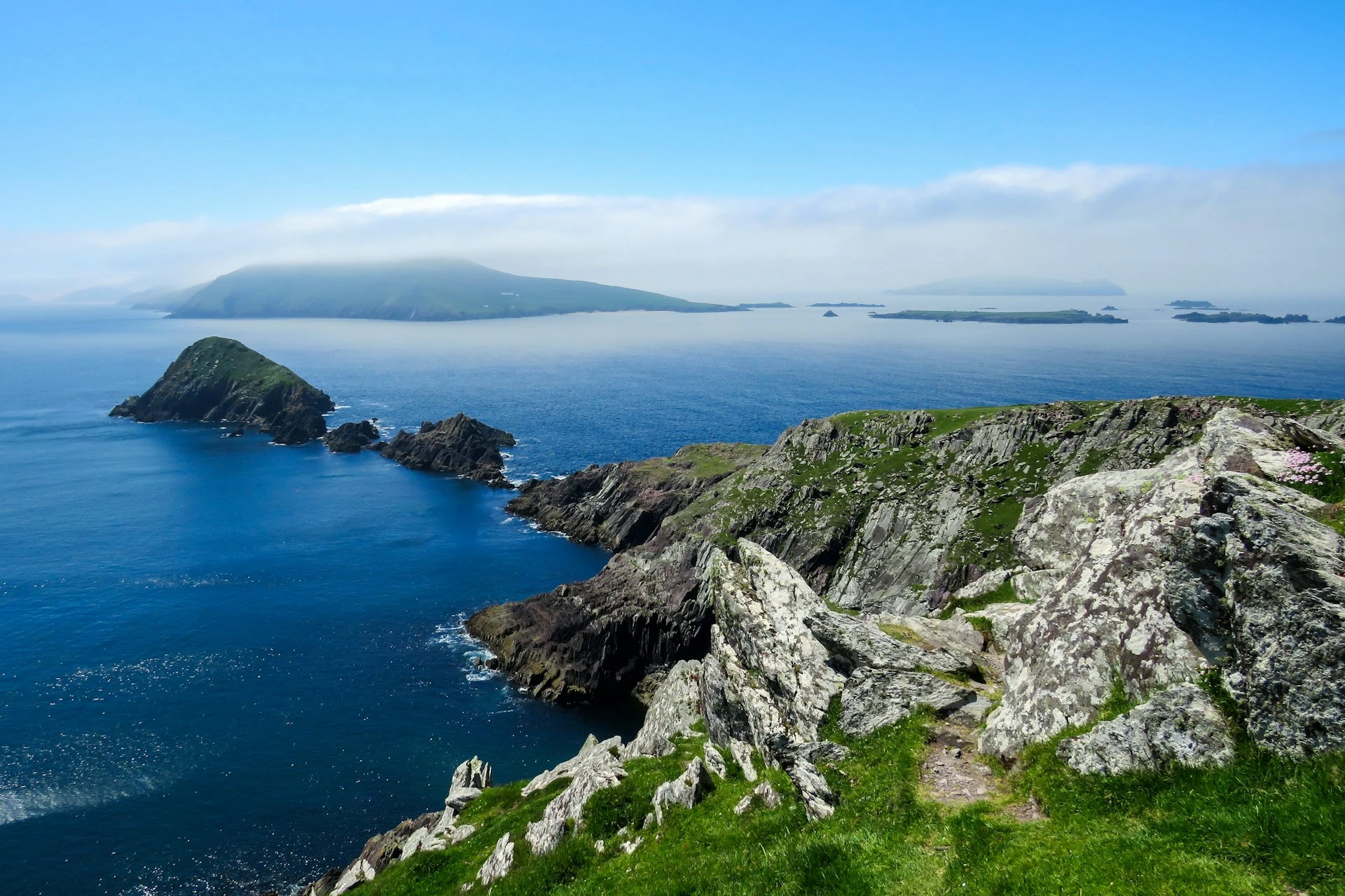
The Dingle Way passes through a variety of environments, including mountains, moors, rocky coastline and sandy beaches, offering hikers the opportunity to immerse themselves in the natural beauty and rich cultural history of this region.
It is a must-visit destination for walkers and hikers seeking adventure and discovery in the wild beauty of western Ireland.
Transportation
The Dingle Way is a loop trail and begins and ends in the town of Tralee. The nearest airports are the ones of Kerry, Cork and Shannon, from which you can then get to Tralee in the following ways:
- Kerry – Tralee (bus or train, about 20/30 minutes);
- Cork – Tralee (train or bus, about 2 hours);
- Shannon – Tralee (bus, about 3 hours).
The largest airport, however, is Dublin, from which you can reach Tralee by taking a internal flight to Kerry and then following the directions above to move from Kerry, or a train or a bus (in this case, however, the trip will take about 5 hours).
Itinerary and stages
Stage 1 – Tralee to Camp:
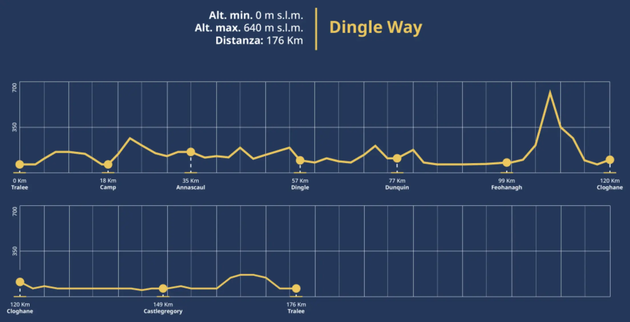
18 Km | 7 hours | +200m
The Dingle Way begins and ends near the Kerry County Museum in Tralee. We begin then, going towards Princes Street and then continuing by turning immediately left through Princes Quay. At this point follow the track immediately to the right for 2km to Blennerville, reaching a bridge on the opposite side of the mill. Now continue across the canal and into the small town. The road then follows the main N86 road in the direction of Dingle for a short distance, and then, after crossing the canal, turns the second left and begins to climb along side roads on the flanks of the Slieve Mish mountain range. Once you travel approximately 3 km from this point, you arrive in Tonavane, pass through sometimes swampy areas and also the entrances to many valleys. Then you go down a stone path and again along a valley, cross the Finglas River, and make a short uphill stretch until you meet a road. At this point turn right and continue for about 1 km to Camp.
Stage 2 – Camp to Annascaul:
17 Km | 6/7 hours | +270m
Returning to the Finglas Crossing Trail, the path continues straight for about 2 km up the valley to an elevation of 235 m, having crossed a saddle between the peaks of Corrin and Knockbrack. Now continue on passing between the mountainous ridge of Moanlaur and Knockmore and on the other side the main Tralee-Dingle road and start downhill again to a small conifer plantation. The Dingle Way continues following this road until it crosses the Emlagh River, after which it comes out on a gently sloping rough path. The trail then starts climbing again behind a row of houses and proceeds inland on small roads and through a field. The last 2 km of this stage will finally lead directly to the town of Annascaul.
Stage 3 – Annascaul to Dingle:
22 Km | 8 hours | +340m
You start from Annascaul and begin by skirting the Tralee-Dingle road for a short distance until you come to a side road, which you follow for a little more than 4 km until you reach sea level, next to the ruins of Minard Castle. Leaving this wonderful beach, we continue along a steep and narrow slope, continuing to follow the trail for about 6 km. Special attention should be paid to the map and directions in this part of the trail, as more than a few people get confused with the road signs for the Tom Crean Trail. You then cross the main N86 road and head north in the direction of Croaghskearda Mountain. Continuing for about 2 km you have to cross farmland and climb the mountain slopes. After traveling a few kilometers, you will come to the Garfinny River, where you must cross the bridge that spans it to head toward the town of Dingle. The trail now crosses the famous paved road through Conor’s Pass, heading north and continues downhill for 4 km until it reaches the destination of this day.
Stage 4 – Dingle to Dunquin:
20 Km | 7 hours | +370m
It begins by heading west along the harbor and crossing the bridge over the Milltown River. At this point you have to follow the main road for one kilometer and then take a secondary road, which you have to follow for about 3 km. We then join the “Pilgrims Route for a few hundred meters before turning off the road for 1.5 km and continuing in a northwesterly direction. At this point the trail passes a saddle at Mám an Óraigh. and then descends to a side road in the direction of Ventry. Then you cross a beach, walking on sand for about 2.5 km, then return to the harder terrain and continue along secondary roads and tracks for another 2 km. Continue along the detour that follows the “Slea Head Road” for just over 1 km and later return to the Dingle Way trail via a right turn. Then, for another 7 kilometers you follow the trail until you return to the main road for the last few kilometers and arrive in Dunquin.
Stage 5 – Dunquin to Feohanagh:
22 Km | 7 hours | +100m
This stage begins uphill to the north and soon turns into a gravel path, which after bypassing the village of An Ghráig descends and rejoins the main road. Then the Dingle Way crosses some grasslands and passes Clogher Beach, then skirts some breathtaking cliffs. Resuming the paved road to the northeast, you come to a T-junction, where you turn right and then immediately left to climb the east side of the golf course. At this point you cross Smerwick Harbor and travel about 6 km of beach until you reach Murreagh and Ballydavid. After passing Ballydavid you continue for 3 km along the cliffs and then, after passing through the Feohangh area you find yourself on back roads through a landscape dominated by mountains and cliffs.
Stage 6 – Feohanagh to Cloghane:
21 Km | 7 hours | +650m
Starting at Feohanagh, the path soon leaves the paved road and heads along an ancient trail that points in the direction of Cnoc na mBristi. We then continue along a strenuous ascent to Mount Brandon, at the peak of which an ancient rock with a cross can be found. When facing the descent from this mountain, it is wise to pay attention to the ground conditions, which could be extremely dangerous after heavy rains, given the high gradient and friability of the terrain. For this reason, it is recommended to use trekking poles for the descent. Next we leave the trail for a dirt road, which continues downhill, but along a less steep and more gradual descent of about 4 km towards the valley. After the descent you can walk a wonderful loop to Brandon Village, then leave the town’s dock and head southwest for a little more than 4 miles to Cloghane.
Stage 7 – Cloghane to Castlegregory:
29 Km | 7/8 hours | +50m
The walk resumes from Cloghane via a quiet road that heads inland, skirting Drom Hill and offering the chance to enjoy breathtaking views all around. It then continues for about 3.5 km before passing the towns of Drom and Farrendalouge and arriving in Fermoyle. Then the trail comes to the longest beach in Ireland (11 km) and continues on the sand for most of its course. This leads to the small town of Fahamore, from which the trail resumes and descends along another stretch of beach about 2.5 km. The very last part of the stage is on a paved road, taking walkers to Castelgregory, the day’s destination.
Stage 8 – Castlegregory to Tralee:
27 Km | 8/9 hours | +300m
This last leg of the Dingle Way begins by heading southeast through a flat, marshy area, but after about 3.5 km the trail joins the main road from Camp to Castlegregoty for 200 meters. Once off the main road, the path returns along the coast, allowing walkers to travel 7 km by the sea. In high tide situations, sometimes some parts of the beach are not passable, so a small detour along the cliff tops will have to be undertaken. After passing Camp Village, the trail comes off the beach and crosses the “Tralee – Dingle Road,” heading toward the lower slopes of the Slieve Mish chain. We then continue along the route already taken on the first leg, but in the opposite direction, for about 9 km, until we reach a quiet back road, which then reaches the larger Dingle Road. Once through Blennerville we continue along the last few miles of the Dingle Way, which follow the canal to downtown Tralee.
Where to sleep
We have selected the best accomodations along the Dingle Way, also differentiating them according to price (for now there’s only a standard configuration, but soon an “economy” and a “premium” configuration will be added). If you book the accommodations through this section you can rest assured, the reservation will be made directly from Booking.com or Hostelworld and you will not pay anything extra, but you will help us continue the project by earning us a small percentage!
- Day 0, Tralee | Tralee Benners Hotel
- Day 1, Camp | Camp Junction House
- Day 2, Annascaul | Adrinane House
- Day 3, Dingle| The Grapevine Hostel
- Day 4 Dunquin | An Portán Guest House
- Day 5, Ballydavid (near Feohanagh) | An Riasc B&B
- Day 6, Cloghane| Mount Brandon Hostel
- Day 7, nearCastlegregory | Beenoskee Bed and Breakfast
- Day 8, Tralee | Grand Hotel Tralee
Videos and Useful Resources
You might find it useful to watch some videos (here we have prepared a playlist of interesting videos) to find out some additional information about the Camino from Santiago to Finisterre. Click on this link to see the playlist on Youtube.
For all always up-to-date information regarding the Dingle Way and every aspect of it you should consult the official site.
Another very convenient site for planning your own route is the following: The Dingle Way Walking Trail | Homepage | Dingle Way
Dingle Way Guides:
Below is a link to one of the few guides, easily found, from the Dingle Way. We strongly recommend that you provide yourself with at least one guidebook, hiking maps or GPX tracks, so that you can tackle the walk as safely as possible.
When to hike it
The ideal period to walk the Dingle Way is between march and october, mainly because of the clearer weather than in the winter period. However, this period is also the busiest, so it is good to check in advance the availability of various facilities for sleeping along the way.
It is also good to remember that in the months between April and September, although they are ideal for traveling the Dingle Way, mosquitoes and very annoying insects, so you must equip yourself with appropriate repellents and protection.
The trail can be walked year-round, but it is good to check the official site any warnings, detours or trail closures.
Markers
The entire path is well marked and traced, by means of paintings, signs and the symbol of a hiker colored yellow. However, it is recommended that you have GPX tracks to follow or a detailed and up-to-date guidebook to consult.
Indicators are typically yellow paints or special signs:

Other routes you might like
West Highland Way
Discover the West Highland Way, a 154-kilometer walk in Scotland through nature and unspoiled landscapes. Get inspired by WalkingEurope!
Laugavegur
Live a breathtaking experience by walking the Laugavegur, Iceland’s most famous path that will take you to discover the far north
The Via degli Dei (5 days)
Discover the Via degli Dei, visiting ancient villages and observing breathtaking landscapes on a 4-night itinerary in the Tuscan-Emilian Apennines.



0 Comments