Via degli Dei
A walk between Bologna and Florence, on the ridges of the Apennines
130 Km, 5 days | Italy
Discover amazing places, visiting ancient villages and observing breathtaking views on a 4-night itinerary in the Tuscan-Emilian Apennines, retracing a route that originated even before the Romans.
Take a journey in search of the history, tradition, art and culinary specialties of the regions you pass through, discovering fantastic traditions and curiosities.
An itinerary that can be traveled even without precise training and can be experienced both in comfort and in search of adventure, offering both cheaper and more spartan accommodations and more expensive and more comfortable refreshments.

Transportation
The Via degli Dei begins in Bologna, a destination easily reachable by train, plane (you can go from the airport to city center by the Marconi Express, cwhich takes about 7 minutes) or bus, depending on your origin.
The hike starts right in the center of the city, at Piazza Maggiore.
As for returning from Florence, you can always return by train, plane or bus, depending on where you need to go. In case you choose to go to the airport you can take, from the city, the tramway T2 leading up to the Florence Amerigo Vespucci Airport.
Itinerary and stages
Stage 1 – Bologna to Badolo:
21,3 Km | 5/7 hours | +820m, -515m
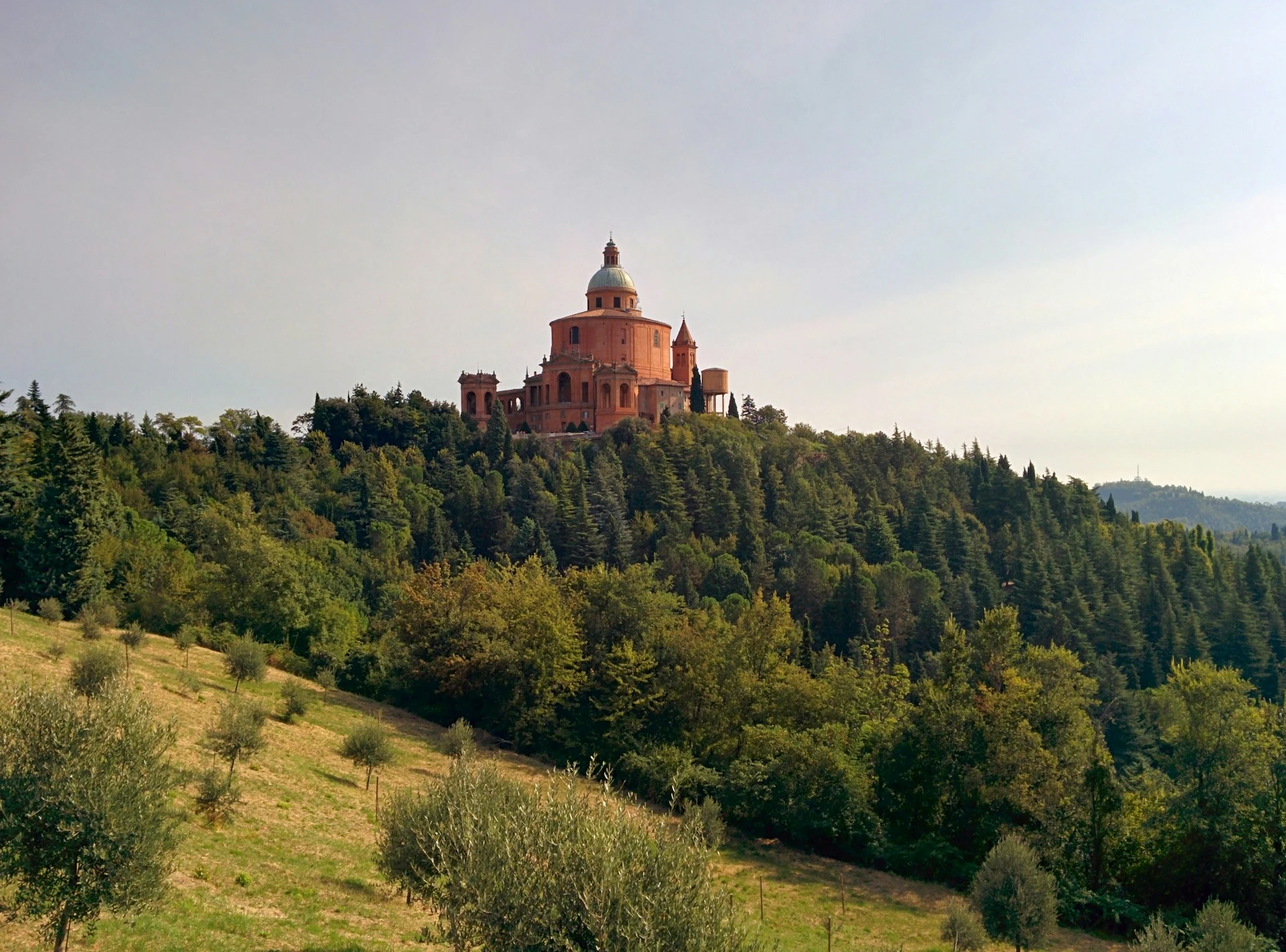
Starting from Piazza Maggiore, we head to Via D’Azeglio, then take Via Farini, Via Collegio di Spagna and Via Saragoza in succession, where there are the last stores and groceries to buy something before the stage begins. We then arrive at the Meloncello arch, from which begins the very long uphill arcade leading up to the Sanctuary of San Luca. Once at the Sanctuary, continue for about 500 meters on a paved road and take the CAI 112A trail on the right to Talon Park. Shortly after the trail begins, it forks: both directions are fine, however, the right-hand path is shorter, but also steeper downhill, so care must be taken. Upon exiting the trail, we then continue following the course of the Reno River and the Via degli Dei and CAI 112 trail signs in the direction of Sasso Marconi. After a few kilometers you come to the San Gherardo Nature Oasis, where there is also a drinking fountain, and continuing further you come to a paved road, which you should follow until you reach the Sasso/Pontecchio junction, where you will need to head for Sasso. At this point, take Vizzano Street and the Via degli Dei continues, arriving at “Ganzole” and Prati di Mugnano. After passing the parking lot, take CAI trail 122 VD, make a sharp left turn and continue on Orchid Street, to be followed until the right turn onto the Badolo provincial road.
Stage 2 – Badolo to Madonna dei Fornelli:
28 Km | 8/10 hours | +460m, -1040m
This stage of the Via degli Dei begins by entering the trail in the direction of Brento. Once you reach this location, you continue past the Monte Adone Exotic and Wild Fauna Protection and Research Center and then turn right along the road that leads steeply uphill to the summit of Monte Adone (following CAI Trail 110 Monte Adone). Once you reach the peak of the mountain, from which you can enjoy a truly splendid view of the surrounding valleys (in my opinion the best vantage point of the entire walk) you resume the trail descending toward Brento, where there are bars and services for resting or stopping to eat. At this point, one must continue the Via degli Dei along the well-marked path, reaching the village of Monzuno (there are bars and services here as well), from which one must continue on a paved road to Madonna dei Fornelli. One must then pass a fork in the road to Loiano and head toward the sports fields, then turn right onto an uphill path. After a few tens of minutes you reach “Campagne” and take CAI Path 19, crossing a gate and coming to the vicinity of a repeater. Now continue on a dirt road to the locality of “Le Croci,” and then climb Mount Galletto and finally arrive at Madonna dei Fornelli.
Stage 3 – Madonna dei Fornelli to Monte di Fo’:
17,1 Km | 5/6 hours | +780m, -750m
This stage begins by taking trail number 19, heading toward Pian di Balestra. Here there will be a crossroads to cross and then continue following the Via degli Dei – Futa and Strada Romana signs, passing a gate and finally being able to admire some sections of the ancient Flaminia Militare. Going further along the track will bring you to a wonderful open green space with a house on the right (“I Capannoni”). So continue further following the clearly visible signs along the trail, until you come to a fork where you have to go right, and then follow the road and take the resume of CAI path 19 that continues to the locality “Piana degli Ossi”. Once you pass Piana degli Ossi, continue walking toward “il Passeggere”, where, at a crossroads with wooden signs, you will have to turn left and continue the path to the next fork, where you must take the right instead. At this point you come to a pretty pond to walk along until the end of the fence. You then leave the woods and arrive at the top of the “Banditacce” and shortly after at the “Pogliaccio,” which is halfway along the entire path. Now continue downhill near the ancient Roman road until you reach the slopes of Poggio Castelluccio. Walking along the path and always following the signs, go to the right and continue following the signs for the Futa, until you reach a paved road, which you should follow until you reach the entrance to the Germanic Cemetery.
Stage 4 – Monte di Fo’ to San Piero a Sieve:
21,1 Km | 6/7 hours | +640m, -1200m
If you start from Monte di Fo’ continue on asphalt until you meet a blue and white bar on the right, which should be passed entering the woods and following the GEA signs, until you reach the locality “Apparita”. At this point you then reach a fork in the road and take CAI trail 00, in the direction of Mt. Gazzaro. It climbs up the hill to its summit, where there is the Cross of Mt. Gazzaro (recently fallen). Now you have to continue along the path, descending and heading toward the Osteria Bruciata Pass, from which you have to take CAI path 46 and descend toward an old abandoned house. From here you walk to a junction, where you must choose the right path (CAI path 46) toward Sant’Agata – San Piero a Sieve and continue to a paved road. At this point you can take the CAI 46 trail parallel to the State Road in the direction of Gabbiano. After a few kilometers the road becomes paved and you finally arrive in San Piero a Sieve.
Stage 5 – San Piero a Sieve to Florence:
32,4 Km | 11/12 hours | +1370m, -1510m
This last stage is very challenging, and you should try to avoid riding it in excessively hot weather.
Start by following the signs to the Medici Fortress and taking the dirt road to the right that is at the top, following the CAI Bo-Fi signs. Still following the signs you come to a paved road, which you take briefly, then turn right, cross the road and turn almost immediately left onto a dirt road.
After a short while you will reach a fork in the road, where you will need to go left on an uphill path from which you can enjoy unique views.
Once Trebbio is reached, CAI 17 Bo-Fi signs should be followed, arriving as far as the highway going to Florence. Then go to Tagliaferro on the left and continue past a gate. Continue to follow the signs until you reach a junction between CAI 00 and CAI 00-60 trails; you must choose CAI 00 arriving at the “Camporomano” clearing and re-entering the forest.
At a certain point you take a paved road and head to the Convent of Monte Senario, where there is a refreshment stand and services. Leaving the Convent behind, follow the road that skirts it downhill along a tree-lined avenue and take a path to the left that descends through the woods to a paved road.
Shortly after, a dirt path begins again, leading to Olmo, surrounded by an expanse of fields. It crosses a road and then ascends toward Poggio Pratone and descends toward Monte Fanna. Now the road becomes mostly paved and
reaches the central square of Fiesole; From here you can take the scenic road downhill, take CAI path 7 and descend to the Maiano quarries, then climb to Settignano and descend back to Florence’s Piazza della Signoria.

Where to sleep
We have selected for you the best accommodations along the Way of the Gods, also differentiating them by price. If you book the accommodations through this section you can rest assured, the reservation will be made directly from Booking.com or Hostelworld and you will not pay anything extra, but you will help us continue the project by earning us a small percentage!
- Day 0, Bologna | Combo Bologna
- Day 1, Badolo | La Casetta di Badolo
- Day 2, Madonna dei Fornelli | Albergo Ristorante Poli
- Day 3, Monte di Fo’ | Podere Belvedere
- Day 4 San Piero a Sieve | Camping Village Mugello Verde
- Day 5, Firenze | Plus Florence
- Day 0, Bologna | Hotel Maggiore
- Day 1, Poco dopo Badolo | Locanda dei Cinque Cerri
- Day 2, Madonna dei Fornelli | Albergo Ristorante Poli
- Day 3, Monte di Fo’ | Podere Belvedere
- Day 4 San Piero a Sieve | Hotel Ebe
- Day 5, Firenze | Coderooms
- Day 0, Bologna | Hotel Metropolitan
- Day 1, Poco dopo Badolo | Locanda dei Cinque Cerri
- Day 2, Madonna dei Fornelli | Albergo Ristorante Poli
- Day 3, Monte di Fo’ | Podere Belvedere
- Day 4 San Piero a Sieve | Hotel Ebe
- Day 5, Firenze | The Social Hub Florence Lavagnini
Credential
The Credential is a fantastic reminder of your adventure and also allows the appropriate bodies to continue to manage the path and constantly improve it.
You can request it online at this link, or at the various distribution points throughout the territory.
Once you have collected your credential, then remember to register on the official website, to contribute to the development of the walk and to also be able to request a free gadget upon arrival!
Find in-depth and updated information for the credential are on the relative page of the official website of the Way of the Gods.
BONUS: free PDF guide!
Videos and Useful Resources
You might find it useful to watch some videos (here we have prepared a playlist of interesting videos) to find out some additional information about the Camino from Santiago to Finisterre. Click on this link to see the playlist on Youtube.
For all always up-to-date information regarding the Via degli Dei and every aspect of it you should consult the official site.
Another very convenient site for planning your itinerary is the following: The Via degli Dei guide: routes, stages, maps and miles (forwalk.org)
Guidebooks:
Listed below are two of what we think are the best guides to the Via degli Dei. We recommend the first (by Walking Nose) to those who want to organize their walk by going slightly outside the standard stages and especially to those who want to tenting; instead, we believe that the second (written by Simone Frignani) is more suitable for those who want to follow a more “standard“
When to hike it
The ideal time to walk the Way of the Gods is between March/April and October/November.
The trail can be walked all year round, but it becomes more complicated in some cases to identify the signage and the trail and to find hospitality in some areas.
In addition, on some occasions, heavy rain or snow may make some parts of the path unwalkable, and that is precisely why it is always good to check for updates and conditions on the official site.
To make it easier for you to find accommodations, especially during winter periods, also on the official website is this page, which lists the main accommodations and refreshments along the route.
Depending on the season in which you wish to walk the trail, then carefully consider your equipment and especially your shoes (in spring/summer we recommend lightweight shoes that dry quickly, although durable and stable, while for winter and fall periods it might be comfortable to wear waterproof shoes that are also good for possibly muddy trails).
Signposting
The entire Camino is well marked and there will be virtually no risk of getting lost , however, it is always good to have brought GPX tracks to follow or a detailed and up-to-date guidebook that you can consult.
Indicators are typically white/red paint or signs.
Other routes you might like
Fishermen’s Trail, Rota Vicentina
Nestled in the spectacular Costa Vicentina, the Fishermen’s Trail offers breathtaking views and pristine beaches along the Rota Vicentina. Learn more about one of the most beautiful coastal paths in the world.
The Camino de Santiago in 10 days
Discover the Camino de Santiago in 10 days from Astorga, walking the last 260 km, crossing fantastic landscapes and meeting unique people.
Cammino del Salento – Seaside Path
Discover the Cammino del Salento and its Via del Mare, 115 km of walking almost entirely along the coast of the Adriatic Sea


0 Comments